Uncategorized
From Scans to Structures: Point Clouds in Architecture
The Future of Architecture: Exploring Point Cloud Technology
What Are Point Clouds?
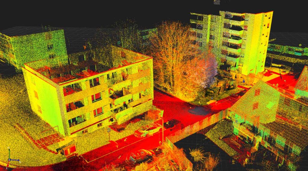
Point clouds are a collection of data points in a three-dimensional coordinate system. These points represent the external surface of an object or environment and are usually captured using 3D scanning technologies such as LiDAR (Light Detection and Ranging) or photogrammetry. Each point in the cloud has a precise X, Y, and Z coordinate, creating a detailed 3D representation of the scanned area.

How Do Point Clouds Work?
The process begins with scanning the environment or object using a 3D scanner. The scanner emits laser beams or captures images from multiple angles, collecting millions of data points. These points are then processed to create a comprehensive 3D model. The resulting point cloud can be imported into CAD (Computer-Aided Design) software, where architects can manipulate and analyze the data.
Benefits of Point Clouds in Architecture
-
Accuracy and Precision: Point clouds provide highly accurate and precise measurements of existing structures and environments. This accuracy is crucial for renovation and restoration projects, where exact dimensions are necessary to maintain the integrity of historical buildings.
-
Efficiency: Traditional surveying methods can be time-consuming and labor-intensive. Point cloud technology significantly reduces the time required to capture and process data, allowing architects to focus more on the design aspects of their projects.
-
Enhanced Visualization: Point clouds offer a rich visual representation of a site, enabling architects to better understand the spatial relationships and context of their projects. This enhanced visualization aids in making more informed design decisions.
-
Seamless Integration with BIM: Point clouds can be easily integrated with Building Information Modeling (BIM) software. This integration allows for the creation of detailed and accurate 3D models that can be used throughout the lifecycle of a building, from design to construction to maintenance.
-
Improved Collaboration: The detailed 3D models created from point clouds can be shared with stakeholders, including clients, contractors, and engineers. This improved collaboration ensures that everyone involved in the project has a clear understanding of the design and construction processes.
Applications of Point Clouds in Architecture
-
Renovation and Restoration: Point clouds are invaluable for renovating and restoring historical buildings. They provide precise measurements that help maintain the authenticity and structural integrity of these structures.
-
Site Analysis: Before starting a new project, architects can use point clouds to analyze the site thoroughly. This analysis includes understanding topography, existing structures, and potential challenges.
-
As-Built Documentation: Creating accurate as-built documentation is essential for any construction project. Point clouds help capture the exact state of a building or site, ensuring that all modifications and additions are correctly documented.
-
Clash Detection: During the design phase, point clouds can be used to identify potential clashes between different building systems. This proactive approach helps avoid costly rework during construction.
Best Practices for Working with Point Clouds
-
Choose the Right Scanning Technology: Depending on the project requirements, select the appropriate 3D scanning technology. LiDAR is suitable for large-scale outdoor environments, while photogrammetry is ideal for smaller, detailed areas.
-
Proper Data Management: Organize and manage the point cloud data effectively. Use software tools to clean, segment, and classify the data for better usability.
-
Training and Expertise: Ensure that your team is trained in working with point clouds and the associated software. This expertise will maximize the benefits and efficiency of using this technology.
-
Integration with Other Tools: Leverage the integration capabilities of point clouds with other design and construction tools, such as BIM and CAD software, to streamline workflows
Need a shadow diagram or daylight assessment?
Fixed-price quote within 24 hours. First draft in 48 hours.
Get a Quote →